Natural History of the Avon River
The Beginning
For at least 10,500 years, and possibly longer, people have been attracted to this part of the world. The beauty of the land, the wonder of the tides and the plentiful resources have compelled people to call this place their home. People have altered the landscape and, of course, the land has altered the people. In order to truly understand history you must understand at least the rudiments of the environment in which it occurred.
For at least 10,500 years, and possibly longer, people have been attracted to this part of the world. The beauty of the land, the wonder of the tides and the plentiful resources have compelled people to call this place their home. People have altered the landscape and, of course, the land has altered the people. In order to truly understand history you must understand at least the rudiments of the environment in which it occurred.
|
The Movement of the Earth’s Crust
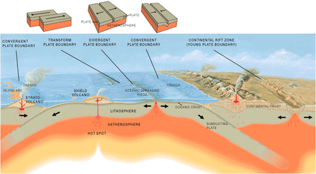
The earth’s crust is composed of large plates which slowly move about on the hot liquid magma which lies beneath them. In the cracks between some of these plates new rock is being formed by magma coming to the surface and forcing the plates apart. These areas are called spreading zones (one such zone runs down the middle of the Atlantic Ocean and is called the Mid-Atlantic ridge). Plates can also collide or slide past each other to form mountains, trenches and faults. These are areas of tremendous energy and it is here where we find the volcanoes and earthquakes of the world. Fortunately, we’re not in one of those areas. Because of the movement of these plates (Tectonic plates) all the continents were once pushed together into a supercontinent names Pangaea that formed about 370 million years ago with Nova Scotia, Scotland and Morocco all adjacent to each other. |
|
 The Gypsum Cliffs in Saint Croix, Nova Scotia,
by local fibre artist Tacha Reed
The Gypsum Cliffs in Saint Croix, Nova Scotia,
by local fibre artist Tacha Reed
The Windsor Sea
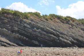
About 350 million years ago (henceforth abbreviated to MYA) those beautiful white cliffs you see as you approach Windsor on Highway #101 were formed at the bottom of a warm shallow sea. The sea existed because of higher sea levels than exist today. It was warm because at that time we were more or less located on the equator.
The sea is named the Windsor Sea by geologists (Hudson’s bay would be a reasonable comparison) and it occupied an area covering this part of Nova Scotia extending westward to Newfoundland and perhaps as far north as the southern coast of Labrador.
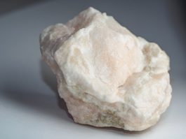
The Formation of Gypsum
Being shallow and warm the water of the Windsor Sea evaporated quickly and as it did the minerals dissolved in the sea water and began to precipitate out. The first mineral to fall out of solution in the process was calcium carbonate which as time and pressure compacted it together formed limestone; next came calcium sulfate which formed Anhydrite. Then calcium chemically combined with water which formed hydrated calcium sulfate or Gypsum.
This process of evaporation wasn’t uninterrupted. Periodically this shallow sea would be flooded with fresh sea water and the process would begin again.
These minerals are often found mixed with siltstone and sandstone which were formed by layers of silt, mud and sand washed seawards by rivers and run-off. The white cliffs and the dramatic formations around us are then, in a sense, the fossilized remains of an ancient sea. Here in Hants County it lies exposed on the surface and varies between one and two thousand feet in thickness making the area one of the largest producers of Gypsum in the world. To give you an idea of the significance of this it’s 99.9% certain that unless you’re reading this outside you are surrounded by Gypsum in the form of wallboard. The only recent form of shipping that came into the Bay of Fundy were the gypsum boats.

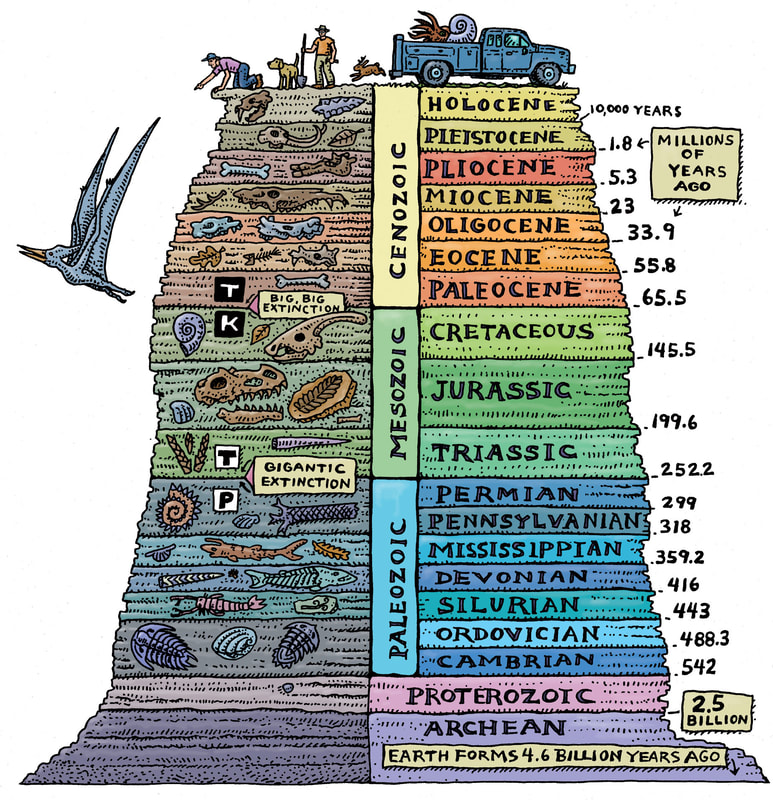
The Scale of Time and the Formation of the Bay of Fundy
Geologists divide time into very large chunks called Eras. The earliest is the Precambrian era which dates from the birth of our planet to 600 million years ago. Next is the Paleozoic era (600 to 230 MYA) and then the Mesozoic (230 to 65 MYA) and finally the Cenozoic era (65 MYA to present).
These are subdivided into smaller chunks of time called Periods. Our landscape was formed during the end of the Devonian period (370 MYA) and on into the middle of the Carboniferous period (310 MYA), or right in the middle of the Paleozoic era, or about 100 million years before the era of the dinosaurs (the Mesozoic).
The Devonian period has been called the age of fishes. On land there were crawling insects, giant tree ferns and the first amphibians. However since we were at the bottom of the sea at that time fossils common in this area are marine.
As Pangaea broke up, a process beginning about 170 MYA and lasting a million years or so, one of the results was that at the end of the Triassic period Nova Scotia was ripped away from New Brunswick. That tear resulted in the Bay of Fundy. The size and shape of that tear resulted in the Bay having the largest tides in the world, particularly here in the Minas Basin.
This is a very simplified version of a very complex process and this description implies that the rift opened, filled with water and that was that. For a more accurate explanation see page 1-6 of “Late Quaternary sea level correlation and applications, (Vaughan Library, Wolfville, QE696.1525 1984)
 Joggins, Nova Scotia
Bibliography
“A Guide to Fundy National Park”, Michael Burzynski
“A Natural History of Kings County”, The Blomidon Naturalist’s Society
“Geological Background and Physiography of Nova Scotia”, Albert Roland
“Coastal Oceanography Workbook”, Dr. Cameron
“Pleistocene Stratigraphy of the Miller Creek Section”, Ralph Stea and Dan Hemsworth
“White Rock”, Edith Mosher
Le Début
Pour au moins 10 500 ans, et peut-être plus, les gens ont été attiré de cette partie du monde. La beauté de la terre, la merveille des marées et les ressources abondantes avaient contraint les gens d’appeler cet endroit leur maison. Les gens avaient altéré le paysage et, bien sûr, la terre avait altéré les gens. Pour vraiment comprendre l’histoire vous devez au moins les rudiments de l’environnement dans lequel elle s’est passée.
Le Mouvement de la Croûte Terrestre
La croûte terrestre est composée de grandes plaques qui lentement bougent sur le magma liquide chaud qui est situé sous eux. Dan les fentes entre certaines de ces plaques le nouveau rocher est en train d’être formé par le magma qui arrive à la surface et force les plaques séparés. Ces endroits sont appelés les zones de répandant (un zone de répandant s’étendu dans le centre de l’océan Atlantique et est appelé le Mi-Atlantique crête). Les plaques peuvent aussi entrer en collision ou dépasser l’un l’autre pour former les montagnes, tranchées et failles. Ceux-ci sont les endroits d’énergie énorme et c’est ici où nous trouvons les volcans et tremblements de terre du monde. Heureusement, nous ne sont pas dans un de ces endroits. Car le mouvement de ces plaques (plaques tectoniques) tous les continents étaient une fois poussés ensembles en un supercontinent appelé Pangée qui a formé environ il y a 370 millions d’années avec la Nouvelle-Écosse, Écosse et Maroc tous adjacent l’un l’autre.
La Mer de Windsor
Environ il y a 350 millions d’années ces belles falaises blanche vous voyez en approchant Windsor sur l’autoroute #101 étaient formé sur le fond d’une mer chaude peu profond. La mer à cause des niveaux de la mer plus haute qu’aujourd’hui. Elle était chaude car à ce temps nous étions plus ou moins situés sur l’équateur. La mer est nommée la Mer de Windsor par les géologues (la Baie d’Hudson serait une comparaison raisonnable) et elle a occupé une région qui a couvert cette partie de la Nouvelle-Écosse étendant vers l’ouest à la Terre Neuve et peut-être aussi loin vers le nord que la côte sud de Labrador.
La Formation du Gypse
Étant peu profond et chaud l’eau de la mer de Windsor a évaporé rapidement et a le même temps les minéraux se sont dissous dans l’eau de mer et ont commencé de précipité.
Le premier minéral de tomber de la solution dans le processus était le carbonate de calcium, alors que le temps et la pression ont le compacté ensemble, il a formé le calcaire; suivant le sulfate de calcium qui a formé l’anhydrite. Puis calcium mélangé chimiquement avec l’eau qui a formé le sulfate de calcium hydraté ou le gypse.
Ce processus d’évaporation n’était pas ininterrompu. Périodiquement cette mer peu profonde serait inondée avec l’eau de mer et le processus commencerait encore.
Ces minéraux sont souvent trouvé mélanger avec le siltite et le grès qui étaient formé par les couches de la vase, la boue et le sable baignait vers la mer par les rivières et l’eau souterrain. Les falaises blanches et les formations dramatiques autour de nous sont alors, dans un sens, les restes fossilisés d’une mer ancienne. Ici en Hants County il reste exposé sur la surface et varie entre un ou deux milles pieds en épaisseur faisant la région une des plus grandes producteurs du gypse dans la monde. Pour vous donner une idée de l’importance de cela, c’est 99.9% certaine que sauf si vous êtes dehors vous êtes entouré par le gypse en forme de la plaque de plâtre. La seule forme de transport maritime qui vient dans le Baie de Fundy maintenant est les navires du gypse.
L’Échelle de Temps et la Formation de la Baie de Fundy
Les géologues divisent le temps dans les très gros morceaux appelé les ères. Le plus tôt et l’ère précambrien qui date la naissance de notre planète à il y a 600 millions d’années. Suivent est l’ère paléozoïque (il y a 600 à 230 millions d’années) et puis le mésozoïque (il y a 230 à 65 millions d’années) et finalement l’ère cénozoïque (il y a 65 millions d’années à la présent).
Ceux-ci sont subdivisés dans les plus petits morceaux de temps appelé les périodes. Notre paysage était formé pendant la fin de la période dévonien (il y a 370 millions d’années) et au milieu du période carbonifère (il y a 310 millions d’années), ou exactement au milieu de l’ère paléozoïque, ou environ 100 millions d’années avec l’ère des dinosaures (le mésozoïque).
Le période dévonien a été appelle l’âge de poisson. Sur terre il y avait les insectes rampant, les fougères arborescentes géantes et les premiers amphibiens. Cependant car nous étions au fond de la mer à ce temps les fossiles communs en cette région sont marines.
Pangée a séparé, un processus qui a commencé environ il y a 170 million d’années et a duré environ un million ans. Un résultat était qu’à la fin e la période Trias la Nouvelle-Écosse était déchirée de le Nouveau Brunswick. Cet accroc a résulté en la Baie de Fundy. La taille et forme de cet accroc a résulté en la Baie avant les plus hautes marrées de la monde, particulièrement ici dans le Minas Basin.
Ceci est une version très simplifiée d’un processus très complexe et cette description insinue que la fente a ouvert, rempli en l’eau et c’était tous. Pour une explication plus précise voyez page 1-6 de « Late Quaternary sea level correlation and application, (Vaughan Library, Wolfville, QE696.1525 1984).
Bibliographie
“A Guide to Fundy National Park”, Michael Burzynski
“A Natural History of Kings County”, The Blomidon Naturalist’s Society
“Geological Background and Physiography of Nova Scotia”, Albert Roland
“Coastal Oceanography Workbook”, Dr. Cameron
“Pleistocene Stratigraphy of the Miller Creek Section”, Ralph Stea and Dan Hemsworth
“White Rock”, Edith Mosher